Showing posts with label pencaitland. Show all posts

Wednesday, 16 June 2010

More Updates

Hi all,

Don't worry; no more useless videos from me for now! Just a quick note on the latest updates for the route. With the original Gifford area now pretty much finished, today's work was entirely on new areas. The countryside between Gifford and Humbie is just under half way done, with about 2 miles of countryside now completed. Still a few more days of work before I can start thinking about Humbie station and preview releases.

As usual, here's some pictures of the latest updates.

The far end of the completed area; mostly just fields and general countryside, but with several interesting features throughout. (Just noticed the roads on the fields on the left. These roads are only there to help in the placement of the fields, for once the decals were removed)

Looking back towards Gifford with the new updates in view

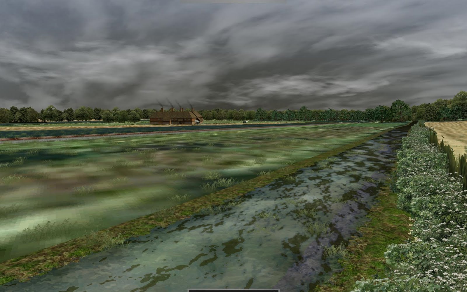
The occasional pools that lie along side the burns are now included.

A picturesque view of a burn passing underneath the railway just after Inglsfield

Another production shot of the route. Unlike with dealing with scenery near the track, where you can use the gradient to accurately maniputlate the surroundings, far into the distance , all I can use is several spot heights as well as extrapolations from contours. Since this only works for small areas, I placed roads from each height, to every other height and then used the embankment tool to take an average of the heights. After further tweeking with the smooth tool, the end result (see the first picture) is realistic and accurate hill that is not generic.

Friday, 11 June 2010

Video Time

Hi Everyone.

Just a video I tried to get uploaded for the last post but it wouldn't let me. It's Derek's Class 101 descending into Gifford station, as it appears now. Word of warning though: I'm utterly rubbish at making videos, so I hope this goes well.

Just some notes about the video.

Firstly, thanks to going over the video, I've noticed a fault with the river (namely, it jumps into the air before it disappears into the forest)

Secondly, the trees as you head into Gifford need to be reworked, or there's going to be many a virtual engineer missing eyes.

Some of you will notice billboards along the route, not befitting the time period. There's a good reason for that. I use billboards as sort of markers along the route. They'll probably still be there on alpha releases. Basically, 1 billboard in the middle of the track is just to help me with navigation and distancing. 2 on either side of the tracks denotes the point of gradient change.

A final note on the Class 101. The Class 101 did actually see service on lines near to the Gifford and Garvald railway as railtours, visiting the area. Unfortunately, by the time that particular railtour arrived at Smeaton, the line from Gifford and Macmerry, all the way to Smeaton, had been lifted. In a similar situation, a railtour woked by a Class 24 also arrived at Smeaton. In the long run, I intend to include both as scenarios, however, you will need the respective addons, to run them (Derek's Class 101, Mesh's Class 24).

Hope you enjoy the video.

Major Updates

Hi again all!

Sorry for the lack of posts of late (seems to be a bad habit of mines). I've still been keeping busy with the route tough. Now, all of the decals between Gifford and Ormiston have been created (backing up the route now takes over 2 hours, but don't worry, there will be no decals in the release!).

Necessity, being the mother of invention and all (as well as RW not being able to utilize my 8GB RAM), has forced me to start removing decals from the route: My idea was to lay the decals between 2 stations, get the track laying and basic landscaping done, then go back and go over the intricacies and remove the decals. However after around 20 decals, RW just crashes when I try to place more decals, so I've now started lifting some of the decals around Gifford. Still a WIP but it now looks a lot closer to how it will in the final release. Here's some more pictures of updates

Flaunting Derek's Class 101 at Gifford
And again, towards Edinburgh. The Class 101 did actually see use on the lines near here in railtours, although the Gifford and Garvald railway had been lifted.

The real deal - barring minor custom work, this is the finished Gifford station and area.

The finished hills and farms near Gifford

Remember those blasted pillars from the last post? Well, they're back, and making my life difficult in decal laying.

Saturday, 8 May 2010

Hi again,

Heres some pics of the latest update. I'm now past the point (In less that 12 hours) that it took me several months to get to before. Probably no more this weekend though, work! Pah!

The view looking up the hills away from Gifford. The hills look more gentle and rolling than before, but this one still hides a nasty 1 in 53 gradient!

As a desperate attempt to get a large farmhouse with a courtyard in the middle, I stapled 4 of the same building together. After adding a conservatory, an allotment and greenhouses, I feel the result isn't actually bad.

Doing a dummy run without decals, this is Gifford station, which is actually now almost complete. It seems a bit empty, but more clutter will be added.

View looking away from Gifford station again with the decals off. The results aren't bad but more work still needs done on the background here.

The real Gifford station was built up so that the station could be level, a fact I neglected before because it made things too awkward, but shown here as a fairly good representation. The eagle-eyed of you will notice that the old 5-compartment carriage isn't present anymore. That's because i can't figure how on earth whoever put it there managed to keep it there without having to build another platform for it!

View looking towards Gifford from the fields.

Miles away from everything, I discovered the results of a furious contest of wits between me and the RW height tool. I had thought I had won, but evedently it got its own back - these pillars extend for many miles in both directions!

Friday, 7 May 2010

Gradients and Giggles

Hi all!

Firstly, my route's been saved by the grace of RW tech support, only downside is that all the track gradients are jumbled. The main line is easy to fix but at Gifford station the track is quite complicated and I don't fancy my chances of being able to re-lay it again, so since the gradients are menial (1 in 85,000!), I'm just leaving it be. Above is the latest development picture, there's not much change, but the run round loop has been completed.

Anyway, all this talk of gradients brings me neatly the article on heights and gradients I wanted to do. My problem with the route is, first and foremost, the fact it no longer exists. Secondly, even in its prime, the route was very obscure (In one of my first posts, I described it as a branch line of a branch line of a branch line of the ECML) and so there's not much information availible on it. All I have to go on, is Google Earth, following the scars in the landscape, and OS map, the railway plans and a book on the railways of Midlothian. This may seem a lot, but theres pro's and cons to each resource. For example, the OS maps offer high detailing of railways, yards, infrastructure and surroundings, but lacks information on signaling and gradients. The railway plans weirdly lack information on the railway (It only covers the main line and not yards or stations) but has excellent gradient information.

With all my resources, I have a good idea of what the surroundings are and where the lines and yards should be. My problem is gradients. The OS maps show spot heights on roads and rivers but not railways as well as contour lines, making accurate gradients difficult. The plans for the railway show excellent gradient information, but only for what was expected of the route, so the actual gradient information is lacking. In the book (The Haddington, Macmerry and Gifford Branch Lines by A.M. Hajducki) there is a gradient diagram from after the construction of the line, the only issue is that the diagram is rather wonkily drawn and so I doubt its accuracy.

The issue list extents when you use all the information together! For example, the hill just outside Gifford is shown as 1 in 50 on the diagram, but only 1 in 53 on the plans. Also, the plans show the whole railway, which was originally supposed to run from Ormiston to Garvald, on which Gifford station is on a 1 in 50 hill, however the line only completed as far as Gifford, there the gradient was leveled to accommodate the terminus.

My solution, is to use the gradient from the plans, then compare it with the information from the OS maps. If the railway ends up 10m above the ground or is otherwise unreasonable, try switching to less accurate diagram and compare results. If it is favourable then use that instead. If it is still unacceptable, then you just have to use a combination of the plans and the diagram, validating it with the OS information, to create an in-between that works. For example, the problem on the hill outside Gifford, I originally tried the 1 in 50 gradient, but this left the railway mid-air, so i tried again with 1 in 53 gradient and it fit rather well!

Well somewhat pointless, but thats my article on why conflicting 110-year-old records are somewhat of a headache to use. More updates soon!

Tuesday, 4 May 2010

A depressing, but nessecary way to go


After buying all the OS maps and spending several hours in the national archives taking measurements, I've decided to restart the route from scratch. The way I've been designing the route so far would cause unnecessary work for me to continue it accurately, and since I didn't get too far with the first run, its not too bad.

The good news is that I now have all the resources I need and I'm also now on my holidays from university (after my exam tomorrow, of course), so I should have good time to work on the route. The picture above shows the very start of my work at Gifford. With the new height information, I now have a base height to use, hence the massive cliffs visible in the top of the picture. These cliffs and other height features will be made to look normal once development continues. Just as a brief thing, I want to do an article about the problems I currently face in terms of gradients on the route, but more on that in the coming days!

Monday, 15 February 2010

Advertising

As you may have noticed, there are now advertisements on the right and at the bottom of the page as well as a donations button on the right. As so many other route developers have mentioned before, getting the resources in order to create an accurate route costs alot of money. I've now realised that I'm going to have to spend money on maps long before I thought I would.

In making my route, I use a book of small map extracts from the time, as well as Google Earth decals (Thank you sooo much RWDecal!) to crate my route. The only issue with that is that between Humbie and Pencaitland, the areal photography is replaced by satalite imagry, which is much lower quality. This is particularly unfortunate since that strech of railway is the most detailed, with the Humbie viaduct spanning one of the many valleys of the area.

My map extracts only show the stations, and when I was viewing records at the NLS, the 1912 OS Maps, dont show the whole length of the line from Smeaton outwards, despite the railway being in existence for around 20 years prior!

My only alternative is to purchase the Bound plans and sections c1900 for the railway, but since the document is over 100 years old, it'll cost around £50 to obtain a copy. The benefits are twofold, firstly, there will be increased accuracy as it mas the whole route in detail, and secondly, it also has a highly detailed gradient profile for the railway, which is important since the gradiant is one of the major characteristics of the line.

It should be noted that I am planning to release the route as freeware (May change that once the route expands) and there is no obligation to give a donation once a release is available. I only have the ads and donations in order to help me along with the route as I'm currently unemployed and at university (not a fun mix). The donations will only be used for supplementing the route and not for any other purpose. I will try to keep you all updated on the balance as I get on.

Anyway, pointless mumble, back to route building!
P.S. sorry for the quality of the ads, not exactly on-topic material!

Sunday, 7 February 2010

The way I roll

Hi all,

Its been about 5 mins since the last post but alright. Forgot to say that if this route goes well, I plan on extending the line from Ormiston to Macmerry then back to Smeaton. And if still going strong I plan to cover the whole Midlothian, East Lothing and Edinburgh area railways! At least noone can fault me for ambition!

The route is going to be split into phases and stages, if you'll forgive me sounding like I'm planning a housing scheme. The phases are as follows;

Phase 1 - Gifford area
Phase 2 - Gifford to Humbie
Phase 3 - Humbie area
Phase 4 - Humbie to Saltoun
Phase 5 - Saltoun area
Phase 6 - Saltoun to Pencaitland
Phase 7 - Pencaitland area
Phase 8 - Pencaitland to Ormiston
Phase 9 - Ormiston area

Each phase will be split into several stages;

[] Decal Capturing and Laying
[] Track Laying
[] Platforms
[] Elevation Mapping
[] Roads and Rivers
[] Buildings and Landmarks
[] Station Scenery
[] Trees, Foliage and Miscellaneous
[] Railway Infrastructure
[] Lineside Infrastructure
[] Industries
[] Decal Removal and Landscape Texturing
[] Final Iterations

Naturally, there will be reiteration all the time on all sections of the route.

You're probably wondering why I'm keeping this so detailed. The reasons are twofold; firstly so people know what still needs done when I come to releasing the route and secondly is for my own benefit, So I know what still needs done. A Key;
[] Nothing Done
[-] On Hold (Back Burner)
[/] Done
[P] In Progrss
[X] Errors or problems discovered
[N] Work planned for next update
[U] Updated in this update

Anyway, first update is going to be up soon!

Introduction to me and the route!

Hi All!,

I'm an Astrophysics student at Edinburgh University but when I'm not at uni, I design computer programs and games as well add-on content for games.

I'm not well known with the Railworks community, most people will know me as the guy who updates the fact page for Mully's Northern Lights route (http://mullys.webs.com/), but none the less, the blog will follow my first decent attempt to make route in Railworks.

The route concerns the state of affairs of the railways circa 1900 in the Mid and East Lothian areas of Scotland. The Gifford and Garvald Light railway is the branch line from Ormiston to Gifford. Even most die-hard railway fans will be scratching their heads here, so to give some ideas of just how remote it is, the line is the branch line of a branch line of a branch line! From Edinburgh Waverley to Gifford was a little over 21 miles. At its starting point, the Smeaton (Smeaton-Shaw Farm) branch branched off of the ECML at Monktonhall Junction and continued to Smeaton station. The route then branched off again, one line joining the Edinburgh and Dalkeith railway at Hardengreen, the other as the Ormiston branch line, which passed by Crossgatehalt (The village of Carberry) then passed several collieries and other works before stopping at Ormiston Station. The line then branched again, one to Macmerry, via Wintorn, then on to several collieries. The other branch line was the Gifford and Garvald Light Railway, which called at Pencaitland, Saltoun, Humbie, then Gifford. The line was supposed to go as far as Garvald (Hence the name) but the funds were unavailable.

The line was slow. Its designation as a Light railway meant that trains could go no faster than 25 miles per hour and there was a limit of 14 tons per pair of wheels. The many levels crossings along the route were always closed to the railway, so at each crossing, the train had to come to a complete halt and the fireman had to get off and open the gate, wait for the train to move by, then close them again. Thankfully this isn't represented in my Railworks route. But don't be fooled by the slow nature of the route! Despite a speed limit of 25 MPH, you'll still be running under full power most of the time as the extreme gradient changes provide a massive challenge to driving the route.

Looking back I'm glad I didn't say a "brief" introduction to the route! But that's the basics of the route, and practically everything about me! Hope you enjoyed it and I'll soon be posting updates about the route.